


Vie Lauretane
Description of Vie Lauretane
Vie lauretane è una guida alla navigazione fisica, sensoriale e culturale del cammino dell’antica Via Lauretana Senese. Basata sulla filosofia di Franz Hessel, flaneur e più grande teorico dell’ “arte di andare a passeggio”, condensata nell’assunto-esortazione: “la strada è come un libro: leggila!” l’App si pone come infrastruttura digitale utile ad approfondire la lettura del territorio e del paesaggio leggibili dalla Via Lauretana.
Oltre a fornire tutte le informazioni di base sul cammino (numeri utili, segnalazioni d’emergenza) l’App Vie lauretane consente di dosare le tappe tarandole sulla base delle esigenze del singolo viator: impostando brevi chilometraggi per pellegrini edonisti che vogliono concedersi più lunghe soste di relax e approfondimento culturale oppure lunghe percorrenze per camminatori più sportivi. Analogamente è possibile scegliere gli standard delle strutture ricettive convenzionate in funzione delle esigenze di budget, comfort e lunghezza della percorrenza.
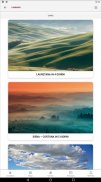
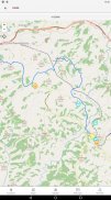
Vie lauretane, con le sue mappe gps interattive e restituite su base di foto satellitare, permette anche di tematizzare il cammino in funzione delle preferenze del pellegrino diversamente animato da istanze: spirituali, edoniste, culturali, fornendo suggerimenti specifici sui luoghi dove contemplare, degustare, apprendere. Un’ampia sezione di contenuti, testuali e audio, relativi alla storia della Lauretana Senese, agli aspetti storico-culturali del paesaggio camminato e delle sue varie componenti, dal borgo alla singola architettura, permette un livello di conoscenza approfondita dei luoghi attraversati dal cammino. Lasciando ampio spazio alla parola e quindi al racconto diretto di una selezione di agricoltori artefici e custodi del Belpaesaggio agrario, Vie lauretane si configura come un medium capace di creare le condizioni utili a stabilire un legame intimo tra il passeggiatore ed il territorio attraversato lungi dal turismo di massa superficiale e veloce. Tale rapporto viene promosso esperienzialmente attraverso un’offerta di degustazioni dedicate agli utenti Vie lauretane e continuamente aggiornate dai produttori.
Per i pellegrini più desiderosi di approfondire la conoscenza dei luoghi visitati l’App fornisce anche la possibilità di prenotare le prestazioni di guide ambientali qualificate e selezionate che possono accompagnare il viandante per un tratto, per una o più tappe.
Essendo sviluppata in collaborazione con l’Università di Firenze l’App si pone anche come un osservatorio nomade sul paesaggio attraversato, un vero e proprio strumento di rilievo e di gestione in quanto, in un’apposita sezione, è scaricabile un questionario atto a rilevare la percezione outsider e a costruire una mappa di comunità che restituisca una rappresentazione percettiva del walkscape che le pubbliche amministrazioni potranno utilizzare nel redigere gli strumenti di pianificazione. In tal modo il pellegrino da turista-spettatore, diviene abitante-attore del paesaggio lauretano.
Altre funzionalità, quali la possibilità di condividere diari di viaggio e album fotografici e quella di rilasciare recensioni permettono di socializzare l’esperienza con la community dei viandanti prima, dopo e durante l’esperienza sul cammino.
Vie lauretane is a guide to the physical, sensorial and cultural navigation of the path of the ancient Via Lauretana Senese. Based on the philosophy of Franz Hessel, flaneur and greatest theorist of the "art of going for a walk", condensed in the assumption-exhortation: "the road is like a book: read it!" the App acts as a digital infrastructure useful for deepening the reading of the territory and landscape readable by the Via Lauretana.
In addition to providing all the basic information on the journey (useful numbers, emergency signals), the App Vie lauretane allows you to dose the stages by calibrating them based on the needs of the individual viator: setting short mileage for hedonist pilgrims who want to allow longer stops of relaxation and cultural study or long journeys for more sporty walkers. Similarly, it is possible to choose the standards of the affiliated accommodation facilities according to the needs of budget, comfort and length of the journey.
Vie lauretane, with its interactive gps maps and returned on the basis of satellite photos, also allows you to thematize the path according to the preferences of the pilgrim differently animated by instances: spiritual, hedonistic, cultural, providing specific suggestions on places to contemplate, taste, learn. A large section of content, text and audio, relating to the history of the Lauretana Senese, to the historical-cultural aspects of the landscape walked and its various components, from the village to the individual architecture, allows a level of in-depth knowledge of the places crossed by the path. Leaving ample space for the word and therefore for the direct narrative of a selection of farmers who were the architects and custodians of the agricultural land, Vie Lauretane is configured as a medium capable of creating the conditions useful for establishing an intimate bond between the stroller and the territory crossed far by tourism fast and superficial mass. This relationship is promoted experientially through an offer of tastings dedicated to Vie Lauretane users and continuously updated by the producers.
For pilgrims most eager to deepen their knowledge of the places visited, the App also provides the possibility to book the services of qualified and selected environmental guides who can accompany the traveler for a stretch, for one or more stages.
Being developed in collaboration with the University of Florence, the App also acts as a nomadic observatory on the landscape crossed, a real instrument of relief and management since, in a special section, a questionnaire can be downloaded to detect the outsider perception and to build a community map that returns a perceptual representation of the walkscape that public administrations will be able to use in drawing up planning tools. In this way the pilgrim from tourist-spectator becomes inhabitant-actor of the Lauretan landscape.
Other features, such as the possibility of sharing travel diaries and photo albums and that of releasing reviews allow you to socialize the experience with the community of travelers before, after and during the experience on the way.
Vie Lauretane - Version 1.0.3
(22-11-2020)Vie Lauretane - APK Information
APK Version: 1.0.3Package: it.pangea.vielauretane


 4.63
4.63


 3.55
3.55


Apps in the same category


